July 3, 2020. It’s always a pleasure to hear from readers. After reading about Harold Keith Howatt’s travels to WWI Germany as part of the post-occupation forces, Helen MacEwen contacted us about a map that her father-in-law sent to his future wife in 1918. “…I have been reading with interest your reports about the WWI Veterans and wondered if I could bring further information about my father-in-law’s last tour after the German surrender. His name was Sgt. Herbert ‘Herb’ S. MACEWEN from Stanley Bridge…”
Helen went on to describe the map. “…I have a copy of the ‘COURSE OF THE RHINE: From Mayence to Cologne’. It is a fold-out map of the Rhine River within a hard-cover. It is very fragile but does mention the different towns that you mentioned in your stories…” (You can read Howatt’s account at The WW1 Soldier Who Went To Post WW1 Germany) Today we know Mayence as Mainz.
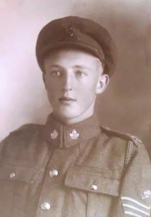
Herbert MacEwen. (Photo courtesy of Helen MacEwen collection)
Howatt was in the 8th Canadian Siege Battery during WWI, while MacEwen was in the 2nd Canadian Siege Battery. Both batteries were later attached to the 2nd Brigade, the only Canadian Heavy Artillery Brigade that went to Germany.
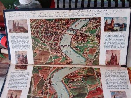
We were intrigued and made arrangements to meet Helen and see the map. It turned out to be a surprise, as it was a foldable, panoramic map in full colour, showing the area along the Rhine River between Mainz and Cologne. To complete the surprise, the map was written in English, but published in Germany. It was clear that this had to be a map that pre-dated WWI and was designed for tourists!

Pieter and Helen MacEwen with the foldable, panoramic map. (Photo credit: Daria Valkenburg)
Ralf Gräfenstein, a historian in Berlin, found a document that might explain why a map published in Germany over 100 years ago would be in English. “…These maps were made in English for tourists from Britain and Overseas, who came before the beginning of WWI and after the war to the German Rhine area…” he explained.
Ralf referred me to a 2006 dissertation written by Thilo Nowack of the University of Bonn, entitled ‘Rhein, Romantik, Reisen. Der Ausflugs- und Erholungsreiseverkehr im Mittelrheintal im Kontext gesellschaftlichen Wandels (1890 bis 1970)’ and gave a reference to the chapters that would be of interest. (Translation of the dissertation: ‘Rhine, romance, travel. Excursion and recreational travel in the Middle Rhine Valley in the context of social change (1890 to 1970)’).
In the dissertation, it was explained that “… the Tourism Society of the Rhine Area was founded in 1904… with the goal “to promote and make traveling and the stay on the Rhine and its side valleys pleasant’…” in response to the view that “… the Rhineland had lost its attraction as a travel destination since the late 19th century…” As part of the tourism promotion effort, “… posters, brochures and other booklets were used to advertise in German, English, French and Dutch…” and placed “…in train stations at home and abroad…” Tourist promotion was economically important as “… the invention and expansion of steam shipping and railroads enabled an enormous increase in travel on the Rhine…”
It seems likely that Herbert MacEwen could have found the map in a shop or train station someplace in Germany, most likely Cologne. It’s clearly a tourist map, with key destinations identified along the Rhine, with brief explanations and diagrams.

An excerpt from the map, showing illustrations and descriptions. (Photo credit: Daria Valkenburg)
Helen noted that “…Herb had sent this map to his girlfriend in Stanley Bridge. They married in 1921. He states that they stayed near Mehlem-on-Rhine…”
At the top of the map Herb had written “… Arrived at the Rhine on December 12th, 1918. I have marked the bridge on which we expect to pass over. We are at present guarding the bridgehead from this site…” This confirms the entry in Harold Howatt’s account, which stated that they had arrived in Cologne on December 12.
Herb MacEwen’s note at the top of the map. (Photo credit: Pieter Valkenburg)
A bridgehead is the strategically important area of ground around the end of a bridge over a body of water. (For more information, see https://en.wikipedia.org/wiki/Bridgehead)
On December 13, Harold Howatt had noted that “….the Canadian troops marched across the Rhine, reviewed as they crossed the bridge by General Plumer and General Currie…” The bridge crossed was the Hohenzollern Bridge in Cologne. (See https://en.wikipedia.org/wiki/Hohenzollern_Bridge)
To our amazement, Pieter found a video from the Imperial War Museum of this march across the Hohenzollern Bridge: https://www.iwm.org.uk/collections/item/object/1060008233.
Herb MacEwen was discharged on May 18, 1919. His daughter-in-law Helen told us that “…he would be 21 years old. He apparently, ‘conveniently,’ put his birthdate down as older than fact when he joined the Army…”
The individual stories of our soldiers enrich the sometimes dry facts of history, and it was wonderful to learn of the shared history of Herb MacEwen and Harold Howatt.
For more information on the post WWI occupation of the Rhineland, see https://en.wikipedia.org/wiki/Occupation_of_the_Rhineland
For more information on General Sir Herbert Plumer, who commanded the Army of Occupation, see https://en.wikipedia.org/wiki/Herbert_Plumer,_1st_Viscount_Plumer
For more information on General Sir Arthur Currie, see https://en.wikipedia.org/wiki/Arthur_Currie
Thank you to Helen MacEwen for sharing the story of Herb MacEwen and Course Of The Rhine Map from the early 20th Century. If you have a story to share, please contact Pieter at memorialtrail@gmail.com or comment on the blog.
© Daria Valkenburg
….Want to follow our research?….
If you are reading this posting, but aren’t following our research, you are welcome to do so. Our blog address: https://onthewarmemorialtrail.com/
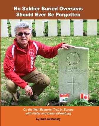 4 countries, 6 weeks, 7,000 km – an unforgettable war memorial journey in Europe…. Daria’s book ‘No Soldier Buried Overseas Should Ever Be Forgotten‘ is available in print and e-book formats. Net proceeds of book sales help support research costs and the cost of maintaining this blog. For more information see https://nosoldierforgotten.com/
You are also invited to subscribe to our YouTube Channel: On The War Memorial Trail With Pieter Valkenburg: https://www.youtube.com/channel/UCJ591TyjSheOR-Cb_Gs_5Kw.
Never miss a posting! Subscribe below to have each new story from the war memorial trail delivered to your inbox.
